GIS
Cal Poly Studio GIS Database
An interactive ArcGIS platform organizing more than 20 years of Cal Poly studio work and 65 plus projects into one searchable spatial dataset.
Role: GIS analysis, spatial data management, StoryMap design
Planning better places through GIS, design, and environmental analysis.
I am an urban planning student at Cal Poly focused on GIS, environmental planning, sustainable urban design, and community centered development. My work connects spatial analysis, policy, design, and real world land management experience.

An interactive ArcGIS platform organizing more than 20 years of Cal Poly studio work and 65 plus projects into one searchable spatial dataset.
Role: GIS analysis, spatial data management, StoryMap design

A walkable, mixed use redevelopment of 230 residential units with a community center and stormwater conscious green infrastructure.
Role: Site planning, illustrative design, circulation

A CEQA style review of a 130 acre concept that uses GIS constraints analysis to site 193 clustered units while preserving over 113 acres of open space.
Role: GIS constraints analysis, environmental review
ArcGIS Pro and QGIS for spatial data analysis, suitability mapping, parcel analysis, buffers, overlays, and clean map design.
View related project →Complete streets, bike and pedestrian planning, transit oriented development, traffic calming, circulation analysis, and multimodal connectivity.
View related project →CEQA and NEPA awareness, habitat restoration, climate resilience, stormwater, wildfire planning, green infrastructure, and sustainable land use.
View related project →Streetscape and public realm design, walkability, mixed use development, placemaking, and detailed site analysis.
View related project →Public outreach, stakeholder engagement, workshop facilitation, survey design, and equity centered, community centered planning.
View related project →Wildfire risk analysis, defensible space, evacuation planning, WUI planning, fuel management, and climate adaptation, grounded in my firefighting background.
View related project →Zoning code review, general and specific plans, land use compatibility, housing policy, environmental justice, and development standards.
View related project →Planning reports, memos, site inventory, precedent studies, policy briefs, staff reports, and academic research.
View related project →Studio teamwork, collaboration, fieldwork, presentation design, deadlines, client style deliverables, and professional communication.
View related project →Environmental GIS and spatial analysis supporting port operations and Puget Sound region planning.
Building an ArcGIS platform that organizes 20 plus years of studio projects into one interactive spatial dataset.
Field tested resilience across large wildfire events, with logistics, fuel management, and emergency response.
Looking for a planning, GIS, or environmental design professional? I'd love to hear from you.
A planning, GIS, and environmental design candidate preparing for full time roles after graduation.
I am Oliver Faase, a City and Regional Planning student at California Polytechnic State University with a minor in Sustainable Environments. My work focuses on GIS, environmental planning, sustainable urban design, land use, transportation, and community centered planning.
I bring a practical perspective to planning through my experience as a wildland firefighter, where I worked in land management, emergency response, logistics, and high pressure team environments. That background helps me think about the relationship between communities, landscapes, wildfire risk, infrastructure, and long term resilience.
Outside of planning, I play club Ultimate Frisbee for SloCORE, where I am a captain this year and serve in leadership as Vice President and Head of Fundraising. I have also volunteered with Search and Rescue, helping train nationally certified SAR dogs.
Explore my planning, GIS, and environmental design case studies.
Planning, GIS, and environmental design case studies, from a 20 year GIS database to a 230 unit redevelopment and a full environmental review.
 Open live StoryMap ↗
A public facing ArcGIS platform that brings more than 20 years of Cal Poly studio projects, over 65 in total, into a single interactive spatial dataset that is easy to explore, compare, and reuse.
I lead the GIS analysis, spatial data management, database structure, and the StoryMap that makes the archive explorable.
I collect and standardize project data, clean spatial layers, review coordinate systems, organize attributes, and improve consistency across historic planning projects so they can live in one unified dataset.
One interactive platform mapping 65 plus studio projects and about 20 years of department history, supporting faculty, students, alumni, and department leadership in research and teaching.
GIS, spatial data management, database design, StoryMaps, research.

Common Ground reimagines an underused site as a connected, medium density neighborhood of 230 residential units in a mixed use block structure, with ground floor commercial and a central community center.
I led site planning and the illustrative design used to communicate the concept, including land use, circulation, and public realm graphics.
I studied the site and surrounding context, tested density and land use options, designed a connected bike and pedestrian network, and developed a stormwater conscious landscape with bioswales and an expanded tree canopy.
A complete neighborhood concept with 230 units, a community center, continuous bike and pedestrian connectivity, generous parks and open space, and green infrastructure that manages stormwater on site.
Urban design, site planning, housing, green infrastructure, graphics.

An environmental planning case study evaluating a 130 acre mixed use residential concept of 193 clustered units, with more than 113 acres preserved as permanent open space, pairing a conceptual design with a full environmental review.
I ran the GIS constraints analysis, the environmental review, and the preparation of a Mitigation Monitoring and Reporting Program.
I built GIS layers analyzing slope, wildfire hazard, hydrology, soils, and biological resources, then used that analysis to steer development away from sensitive and high risk land, and reviewed air quality, noise, and utilities.
A clustered development pattern that preserves more than 113 acres of open space, places 193 units on the least constrained land, and carries a documented environmental review with mitigation measures.
GIS, environmental review, CEQA style analysis, wildfire and hazard analysis, hydrology.

The Nipomo Master Plan addresses long term growth through new housing, mixed use districts, open space, and circulation, while respecting the area's rural identity and the cultural history surrounding the Dana Adobe.
I contributed to land use planning, circulation, stakeholder informed design, and mapping.
I incorporated stakeholder feedback, planned land use and circulation, structured open space and districts, and worked the rural and historic context into the plan.
A master plan that balances new housing and mixed use districts with preserved open space, stronger circulation, and protection of local rural and cultural identity.
Master planning, community engagement, housing, circulation, open space, mapping.

This redevelopment reworks the Olive Street and Santa Rosa intersection into a denser, more walkable place, with protected bike lanes, a transit stop, courtyard housing, and a lively public realm.
I designed the street and block redesign and programmed the public realm amenities.
I redesigned the intersection and street section, studied density, floor area ratio, and parking, and programmed public amenities including a courtyard, a food truck court, a playground, and street parking.
A more walkable corridor with protected bike lanes, a transit stop, courtyard housing, and active ground floor uses framed by a redesigned intersection.
Urban design, multimodal circulation, density and floor area ratio, public realm design.
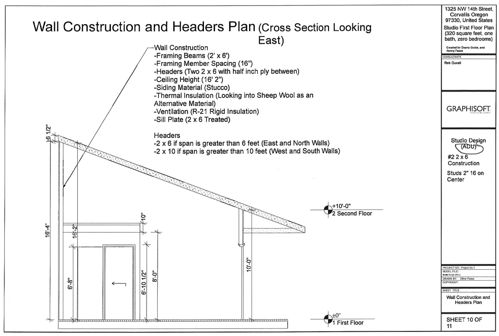
This capstone takes an accessory dwelling unit from initial zoning research all the way to permit ready construction documents, focusing on real code and permitting requirements.
I handled the code and zoning research, the 3D modeling, and the construction documentation.
I researched zoning and building code, confirmed permitting requirements, modeled the unit in SketchUp and Revit, and prepared construction documents.
A code compliant ADU design with permit ready construction documents that demonstrate zoning, building code, and documentation fluency.
Zoning analysis, code compliance, 3D modeling, construction documents, Revit.
Download the complete PDF or get in touch to talk through any project.
GIS, environmental, and field experience. My wildfire background feeds directly into how I think about resilience, land management, and the real constraints communities face.
Environmental GIS and spatial analysis supporting port operations, sustainability initiatives, and planning across the Puget Sound region. Produced mapping and spatial data that inform environmental decision making and connect port activity with the surrounding landscape and waterways.
Building an ArcGIS based platform that organizes more than 20 years of Cal Poly City and Regional Planning studio projects into a unified and interactive spatial dataset. Responsibilities include collecting and standardizing project data, cleaning spatial layers, reviewing coordinate systems, organizing attributes, and improving consistency across historic planning projects. This work supports faculty, students, alumni, and department leadership by making past studio work easier to access, compare, and use for future planning research and teaching.
Supported wildfire suppression, fuel management, logistics, and land management operations across large scale fire events in the Pacific Northwest and Idaho. Worked in high risk field conditions while coordinating with crew members, maintaining equipment, supporting fire camp operations, and applying fuel assessment techniques to reduce fire spread and protect structures. This experience strengthened my understanding of wildfire risk, landscape management, emergency response, environmental resilience, and the importance of planning for communities at the wildland urban interface.
Reach out about planning, GIS, or environmental design opportunities.
What professors and instructors have said about my work, including a letter of recommendation from my GIS professor in Copenhagen.
You made me feel so proud, Oliver, and I loved watching you improve with each speech. This was an outstanding demo and I was really impressed. Great job, and be sure to reward yourself!
Your proposal was a pleasure to read. I'd love to see this published, either in Fresh Voices, the campus newspaper, or as an editorial in a local publication. You did a superb job and should be very, very proud.
A very good urban design exploration which has resulted in a thoughtful and intentional project. Well done!
I can confidently recommend Oliver for roles involving GIS analysis, spatial data management, and web based map development.
I am pleased to write this letter of recommendation in support of Oliver Faase. As an external lecturer at DIS, Study Abroad in Scandinavia, I had the pleasure of being Oliver's professor during the Fall 2025 semester in the course Geographic Information Systems: Applied Climate Change Cases.
During his time as my student, Oliver was punctual and actively participated in classroom discussions, helping to stimulate and enrich the classroom experience. Oliver proved to be a dedicated and diligent individual, and I believe these qualities testify to his potential as a GIS professional and his ability to take on independent technical challenges.
GIS is a complex program, and throughout the semester Oliver proved he was independently motivated and proactive in his work by creating thorough and complete assignments. When students were encouraged to gather additional datasets for their final projects, Oliver acquired data from outside the class and independently cleaned, structured, and prepared it for spatial analysis. He demonstrated strong analytical skills, attention to detail, and the ability to troubleshoot technical issues when workflows did not initially function as expected.
In addition to his technical skills, Oliver showed persistence and composure when working through challenges, which is an important quality when working with GIS platforms and web based applications. His structured approach to problem solving and willingness to independently research solutions make him well suited for tools such as ArcGIS Experience Builder. I am confident in his ability to learn new GIS software environments and apply his foundational knowledge to develop interactive and well organized mapping products.
Based on my experience with Oliver, I can confidently recommend him for roles involving GIS analysis, spatial data management, and web based map development. His motivation, technical competence, and professional attitude will make him a valuable addition to any team.
Best regards,
Rasmus Ekman
External Lecturer, Environmental Science of the Arctic, DIS
GIS Specialist, Department for Sustainability, City of Copenhagen
Reach out anytime with questions, comments, or opportunities. I'd love to connect.
Email is the quickest way to reach me. You can also download my resume and portfolio or find me on LinkedIn.